Fforest Fawr Geopark
11 March 2015
Alan Gowring – Geopark Development Officer
Introduction
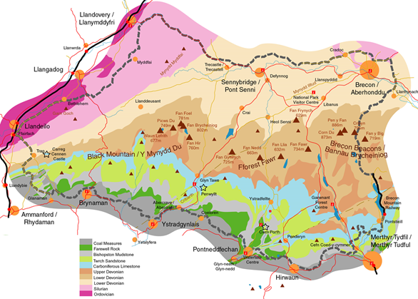
The British Isles have the most diverse geology in the world and the Fforest Fawr Geopark has a diverse collection of mainly sedimentary rocks going back in time to the Ordovician (480 MYA). The oldest rocks are in the West and the youngest (Carboniferous) in the East (280MYA). To the South are Coal Measures and ‘Farewell Rock’ (see later)
The Geopark is not just about rocks but also about archaeology and the people that lived in the area from the earliest settlements to the Industrial Revolution.
The Geopark forms the Western part of the Brecon Beacons National Park. This area is the least visited in the park and one of the main aims of the Geopark is to aid the development of the area.
Alan used the analogy of a layered sponge cake to describe the Geopark:
· The layers of sponge
o Sandstone
o Mudstone
o Limestone
o Coal
· The Icing on the top
o The effects and legacy of Glaciation
· The figures on top of the icing
o our own legacy – the hunters, gatherers, farmers, storytellers, soldiers, worshippers, foresters, miners, travellers, scientists, innkeepers
The ‘Sponge’ Layers
The oldest layers are the Ordovician Sandstones. The word Ordovician derives from name of the Celtic tribe, the Ordovices. Similarly the Silures tribe gives its name to the Silurean Period.

The geology of Wales was first investigated and described by Sir Roderick Murchison who named the Silurian System and by Charles Lapworth who named the Ordovician System. In doing this they laid the foundations of Modern Geology.
The Ordovician sandstones were laid down in the Welsh basin at the edge of the closing Iapetus Ocean as Avalonia and Laurentia came together to form Laurussia (‘The Old Red Continent’). This gave rise to the so called ‘Old Red Sandstone’ which actually comes in a variety of colours ranging through Red, Green, Grey and Black. Much of it is actually Mudstone! This rock type makes up about 50% of the Geopark and is found in the West.
In the Devonian period the closing plates caused the Caledonian Orogeny and built the Scottish and Welsh mountains.
Later in Devonian Britain the erosion of the Scottish mountains brought sediment down in rivers to Wales and formed hard well cemented sandstone which can be seen at sites like Pen-y-Fan.
In the Early Carboniferous Period Laurussia had moved northward to the Equator and Wales had been submerged in a shallow sea. This resulted in the deposition of Limestone in surroundings similar to today’s Florida Keys.
This limestone is seen in the Geopark as a ‘Karst’ landscape running East-West with limestone pavements and extensive world class cave systems like Ogof Ffynnon Ddu.This limestone has been heavily quarried for building and also burnt in limekilns to produce quicklime.
The limestone at Dinas Rock dips steeply due to its proximity to the Neath Disturbance – one of a series of ancient weaknesses in the Earth’s crust along which the rocks have been faulted and folded in the Variscan orogeny.

In the later Carboniferous period (325-310 MYA) plate tectonic movement created the supercontinent called Pangea. This produced the Twrch Sandstones (aka Millstone Grits) and coal measures within the Geopark. Subsequent weathering of the Twrch Sandstone resulted in ‘Silica Sand’ which is used to make refractory bricks. This combination of limestone, coal and silica sand resulted in the industrialisation of South Wales. At the bottom of the coal measures the first layer of Sandstone has come to be known as the ‘Farewell Rock’ so named by the coal miners as marking the end of the coal and indeed the mine!
The periods following the late Carboniferous are not present in the Geopark.
The Icing
This represents the last few hundred thousand years and the legacy of glaciation in the Geopark landscape. Glaciers covered the whole area of the Geopark in several cycles
Evidence of glaciation can be seen in glacial striae in the Twrch sandstone and lumps of rock strewn across the landscape (‘Erratics’).


The Figures on the Icing
This last ‘layer’ concerns the effect that man has had on the landscape. This is evidenced in the geopark as follows:
· Middle/Late Stone Age (8000 – 2400 BCE)
o Hunter gatherers (Waun Fignen Felen)
· Bronze Age (2400 – 700 BCE)
o Standing stones & burial mounds (Maen Llia, Ystradfellte)
· Iron Age (700 BCE– 48 AD)
o Hill Forts (Y Gaer Fawr, Garn Goch)
· Roman Period (48 AD – 400 AD)
o Forts, Roads, Camps, Gold Mines (Y Gaer, Brecon)
· Dark Ages (400 AD – 1000 AD)
o The age of the Saints
o Churches, Welsh language, Yew trees (Church at Llanddeusant, Saint’sTeilo & David)
· Norman Period (1086 AD – 1283 AD)
o Castles and Mottes (Brecon, Hay, Abergavenny)
o Royal Hunting Ground (Fforest Fawr)
· Mediaeval Period (1283 – 1536)
o Castles (Carreg Cennen Castle
o Farms
· Industrial Revolution (1760 – Present)
o Mineral Extraction (Coal, Ironstone, Limestone)
o First tramway systems for mining
o Wales becomes the first industrial nation
Dick Harris, June 2015